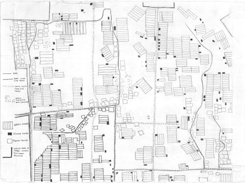
This map of Rags chu village in Rnga chen township was hand drawn by Jeff Lodas. It is roughly to scale. The village extends approximately 1300 meters from north to south and 1150 meters from east to west. Each lightly marked grid block (visible at the edges of the original map) represents 100 square meters. Just north of the three walled areas is Najing (Rnga chen) road. The north-south tree-lined road which runs down the southern half of the map close to the left side separates Grong gsar from Rags chu village, with Rags chu on the right (east) and Grong gsar to the left (west). The boundary extends northwards towards Najing road but is not marked by a path. At the very left-bottom (southwest) corner of the map the cluster of Tibetan houses belongs to 'Khrung lha village, which was renamed Dar dmar (Red Flag) village in 2001. The boundary here is the southernmost road shown on the map. The dense cluster of houses in the upper-right hand corner (northeast) of the map is Rgu tsha village. The boundary between Rgu tsha and Rags chu runs roughly from northwest to southeast, from the intersection between the two large walled compounds in the center-top edge of the map down to the intersection of the road with a canal in the center-east of the map. While the map is primarily of Rags chu village, it also shows small parts of Grong gsar and 'Khrung lha, and a slightly larger part of Rgu tsha village.
Resource #: 29465 (URL for reference)
Collections: Lhasa - Cultivated Landscapes, Emily Yeh Landscapes (2002)
Associated Resources
Resource type: Image
Photographer: Emily Yeh
Photograph Date: 12/Jan/2006